An easy way to zero in on state’s hazard zones
Showing where ground can break
Interactive online map shows places at risk in an earthquake

It’s now way easier to find out if you live in a California earthquake fault zone.
The California Geological Survey has published an easy-to-use interactive map online — type in your address or share your location on your smartphone, and,
Or, for that matter, a place at risk of liquefaction or a landslide unleashed by an earthquake.
What these three zones have in common is the risk the ground can break in an earthquake, and not just be shaken.
“When the ground breaks under an existing building, there’s a higher chance that the building will collapse,” said Tim McCrink, supervising engineering geologist and program manager for seismic hazards for the California Geological Survey.
State lawmakers ordered the creation of these maps decades ago as a matter of public safety. But they have been published either in paper form or in unwieldy PDF files, and they were a nightmare for prospective home buyers trying to figure out whether their possible dream house was in a hazardous zone.
No longer.
Here’s an explainer of what this all means.
It means you’re in an area at risk of the ground breaking in an earthquake.
Not all such areas will actually see the ground break apart in the next big quake. That depends on where the earthquake is, and which faults move.
There are several ways.
Liquefaction can also cause something called “lateral spreading,” in which the ground can slide down gentle slopes or toward the bank of a river while on top of a buried layer that acts like a liquid.
“Because sand is behaving like a fluid, anything on top of it is going to slide,” McCrink said. “Because that material at depth is behaving like quicksand … gravity is going to push it down, even on a very small slope.”
This occurred during the 1994 Northridge earthquake on Balboa Boulevard in Granada Hills, where a gas main was ruptured by lateral spreading and caught fire.
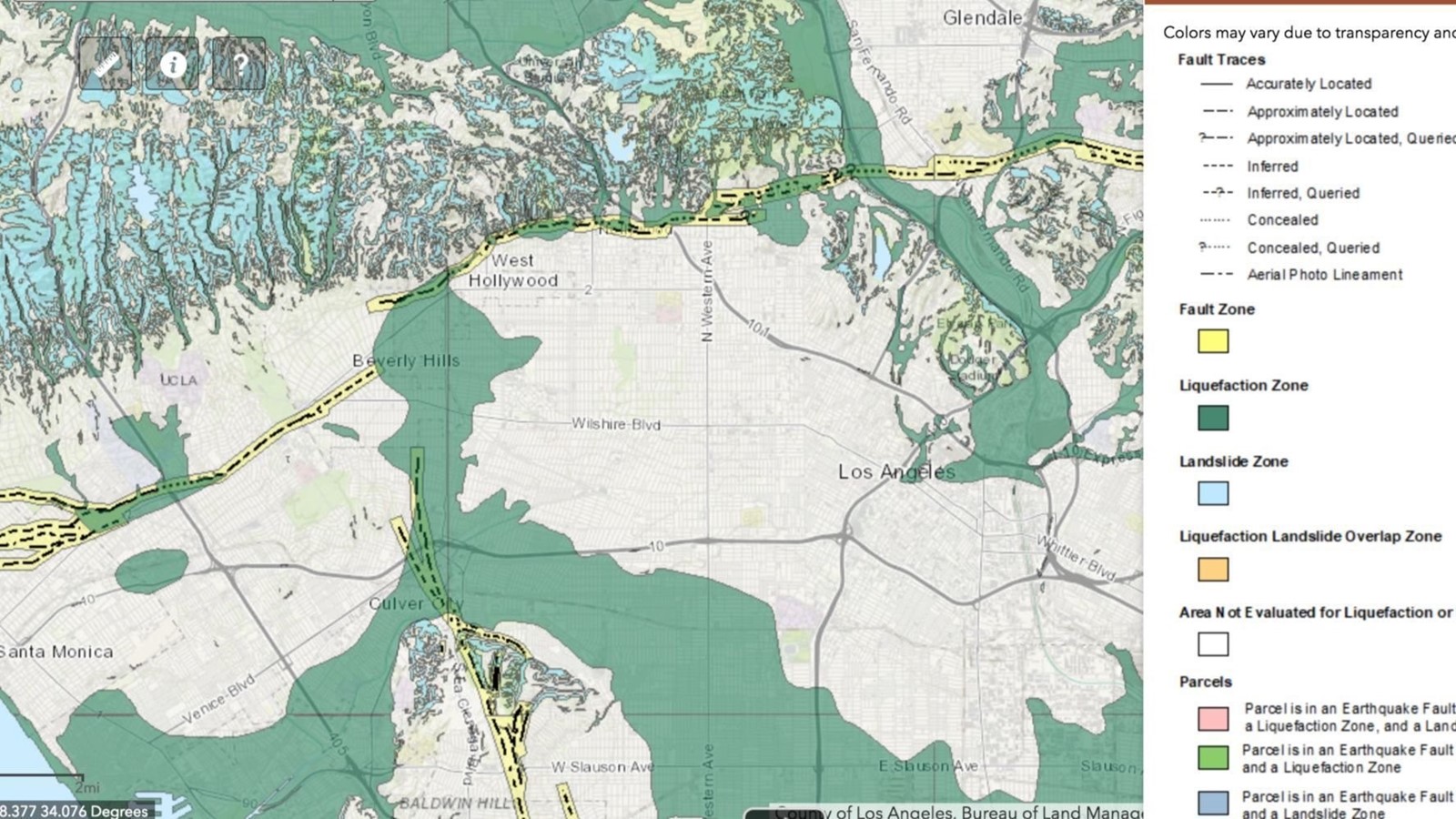
The southern half of the San Fernando Valley is a large liquefaction zone.
Liquefaction zones also exist in large swaths of the L.A. Basin and Orange County. They are based on groundwater levels and the deposit of young sediment from the mountains in the region; some of the zones follow the route of rivers.
The map will show which parcels are affected by which zones.
For instance, if you type in the address to Beverly Hills City Hall at 455 N. Rexford Drive, you’ll see a zoomed-in parcel covered in yellow. If you click on the parcel labeled “455,” the website will say that all or a portion of the parcel lies within an earthquake fault zone, but not a liquefaction or landslide zone. An icon in the upper right offers a legend explaining the map’s colors.
Be aware of the risk. You can also speak to your city or county building officials to see if they have more geological information about your particular area.
But the real focus of this information is intended for people planning new construction or a significant renovation.
The main point of these maps is to flag for developers and prospective buyers what they’re getting into — that there
“An important thing to keep in mind is that the zones are a broad area where hazards may exist,” McCrink said. “The area where the ground actually fails in a particular earthquake may be only a small proportion of the total area in the zone.”
The zones are intended to tell local building officials to instruct developers to order a special study before new construction or a major renovation is allowed.
In the case of an earthquake fault zone, a geology investigation may conclude that the property, while near a fault, is not on top of the actual fault line — and an owner is free to build.
Similarly, further investigation may end up showing there is no risk of landslide or liquefaction on a particular parcel.
But if there is a problem, steps can be made to improve safety.
For instance, a developer can try to move the building’s footprint to avoid the fault line. State law generally bans building on top of fault lines.
An owner may also choose to avoid building in areas with a confirmed landslide or liquefaction risk.
There are also other options.
To reduce the risk of damage from liquefaction, crews can put in deep foundations or reinforced shallow foundations, McCrink said. To address landslide risk, crews can modify or dewater land or create some kind of protective wall structure.
Once construction is complete, it can be more difficult and costly to address the problem.
“It’s not a deal-killer just to have a property in the zone,” McCrink said. “Knowledge is power.… Before you buy your property, before you build ... do an investigation to see what your hazards are.”
Yes. The Natural Hazards Disclosure Act requires that anyone selling property disclose to prospective buyers that the land lies in a hazard area.
Go to